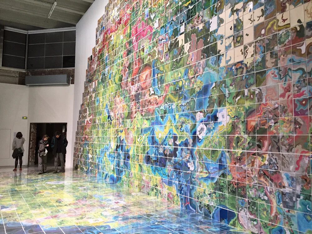
Jerry's Map: A Doodle from 1963 That Became a 4,000-Panel World
Jerry Gretzinger's map began in 1963 as a doodle, spent years forgotten in an attic, and is now a two-dimensional world of more than 4,000 panels that keep changing according to instructions drawn from a deck of cards.
A doodle that became a 4,000-panel world
In the summer of 1963, Jerry Gretzinger began drawing a map of an imaginary city. It started as a doodle made in the spare time left by a tedious job, and he kept adding to it for two decades until, in 1983, he set it aside. The map gathered dust in the attic of his home in Cold Spring, New York, until his son Henry found it while rummaging around, brought it downstairs and asked what it was. Seeing it again prompted Jerry to dust it off and continue.
Today Jerry's Map is a two-dimensional "virtual world" art project made of more than 4,000 individual eight-by-ten-inch panels. Assembled, they form an approximate circle, and each panel's place is fixed by north, south, east and west coordinates that originate at the centre of that circle. The locations do not change; the panels themselves are revised again and again. The media are acrylic, marker, coloured pencil, ink, collage and inkjet print on heavy paper, and every change follows an elaborate set of rules combined with randomly generated instructions.
The deck of cards runs the work
That randomness comes from a custom deck the artist drew himself. A cycle begins only when the tasks on the previous card are finished, which can take minutes or days. The cards started out as a simple random number generator: "I wanted to move through the stack faster, and the easiest random number system I could come up with was a deck of cards," Jerry recalls. "I'd draw a card and move down that many panels in the stack." Instructions came later; the current deck, adapted from playing cards, holds roughly 100 cards and changes as cards are added, revised or removed.
The accompanying rules are precise. Each card carries a large black or red number in a corner, and a "task" means covering that many work units, one work unit being a number of one-inch squares — so a day's work may be one card or only part of it. The colour of the card sets the direction of work: black is clockwise, red is counter-clockwise. Each page has a centre point from which the work spreads, new panels appear when a "new panel" card is drawn or when a section needs completing, and a new page takes the "colour of the day". New artwork is never painted over an original; it is added to a new version of the page.
Layers, from paint bands to the Flood
The map is built in successive layers, each replacing the one before. The base layer starts with a blank eight-by-ten-inch patchwork of paperboard or a sheet of heavy paper carrying a photograph or a lumen print, then fills with bands of painted colour, then with one-inch squares of paper collage, and finally with one-inch city squares: green with 400 new inhabitants, red with 800, grey with 1,200 and black with 2,400.
SiTech — AI-powered web development
We build fast, modern websites and bring AI into real business workflows. Have a project or a question? We'd love to help.