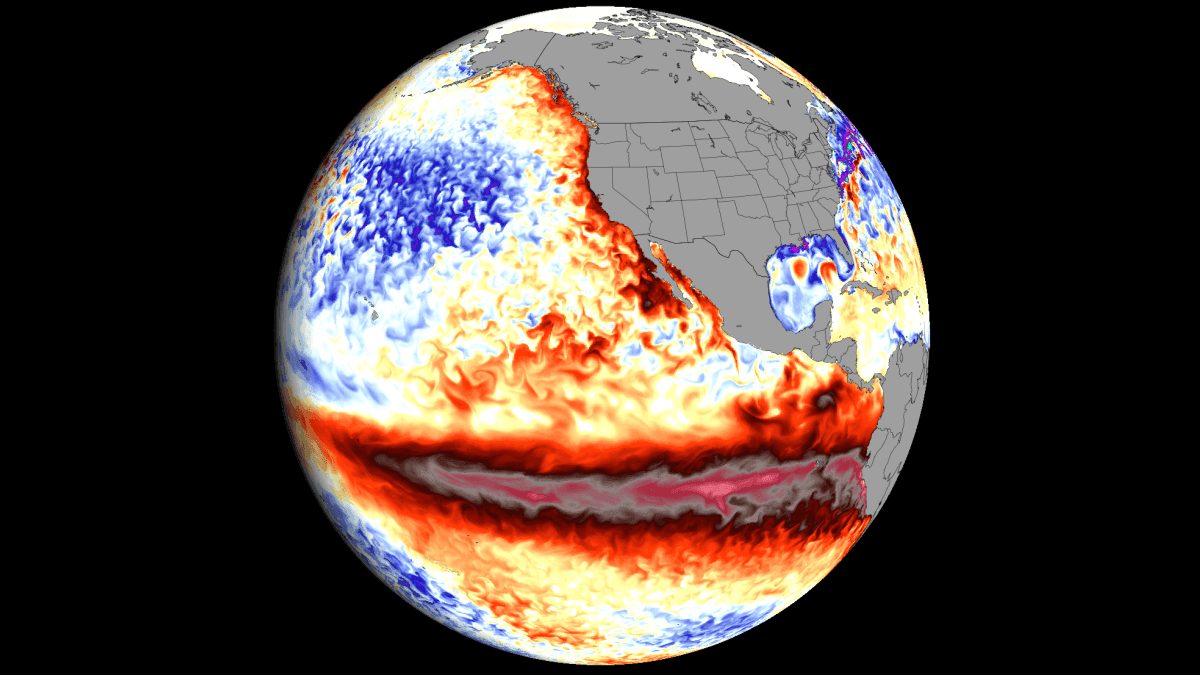
Super El Niño Keeps Growing as Forecasts Reach Record Territory
New ocean and atmospheric data show the 2026 Super El Niño accelerating toward record strength, with forecasts now pointing to a highly amplified Winter 2026/2027 pattern.
Super El Niño continues to strengthen rapidly across the tropical Pacific, and new ocean and atmospheric data show another acceleration in its development. The latest long-range forecasts have raised the projected peak again, pushing the 2026 event deeper into historic territory, according to an analysis published by Severe Weather Europe on August 12, 2026.
Record westerly winds and a powerful Kelvin wave
Behind the rapid growth is an unusually strong combination of westerly winds and subsurface ocean heat. A zonal wind ranking for June and July 2026, calculated from ERA5 data, shows that a broad region of the western and central equatorial Pacific recorded its strongest low-level westerly wind anomalies of the past 86 years, with surrounding areas ranking in the top five. NOAA CRW analysis shows surface warm anomalies peaking at more than 6 degrees Celsius above normal, while a downwelling Kelvin wave carries anomalies above 9 degrees Celsius (16°F) in the top 250 metres, moving eastward and rising toward the surface.
Record readings in the indexes
The 2026 event has already surpassed the 2015–2016 Super El Niño in speed and strength after one of the fastest development cycles in decades. NOAA's Multivariate ENSO Index (MEI) reached a record June–July value of +2.4, the highest for that period since the record began in 1979, climbing from −1 in February–March in just four bi-monthly periods. A Super El Niño is commonly defined as sea surface temperature anomalies of at least +2°C in the main ENSO region; current forecasts exceed the informal +3°C threshold in many scenarios and approach +4°C in some ensembles. Each of the last seven ECMWF runs has shown a stronger peak.
Fall and Winter 2026/2027 outlook
The atmosphere is already responding: the Walker circulation has locked into what scientists call an atmospheric standing wave, with rising air over the central and eastern Pacific and sinking air over the Indian Ocean, and ECMWF's extended forecast keeps that structure nearly stationary into late September. For Fall, the forecast shows a more evolved pattern than usual, closer to a typical El Niño winter: a high-pressure anomaly over Canada, the Pacific low and a storm track across the southern United States, plus a North Atlantic low reaching toward the UK and Ireland that brings warmer air and above-normal precipitation over much of Europe. The December–February outlook shows a deep North Pacific low and a blocking high over Canada, favouring milder conditions in the north and cooler, wetter weather across Texas, the Gulf Coast and the Southeast. The February update suggests the pattern shifts east, with a potentially colder mid-to-late winter over parts of the United States and above-normal snowfall potential across the Central and Eastern U.S. and southeastern Canada, while Canada, the Pacific Northwest and the northern Great Lakes are forecast below average. Europe should see mostly above-normal temperatures under a dominant westerly flow, with snowfall potential limited mainly to the north, the northeast and central high elevations. The author cautions that the February pattern is a developing trend, not a fixed forecast.
SiTech — AI-powered web development
We build fast, modern websites and bring AI into real business workflows. Have a project or a question? We'd love to help.